Winter is a quiet time in North Topsail Beach, N.C. Pastel-painted homes and condos sit like empty Easter eggs, their windows boarded against winter storms. Some property owners upgrade and repair their homes during the off-season, preparing for summer’s surge of visitors. Hammers and skill saws interrupt the rhythmic sounds of breakwater, wind and seagulls.
 North Topsail Beach is one of three small towns located on Topsail Island, a barrier sand spit that hosts about 6,000 year-round residents. During the summer, that number swells to 60,000. Tourists clog the roads and their brightly colored umbrellas dot the beach. But in January, it’s hard to imagine that the island generates $110 million in beach recreation revenue a year.
Full-time residents say they enjoy winter’s serenity. At low tide, families and neighbors walk the beach, looking for shark teeth and sand-polished fragments of glass.
“It still gives me goosebumps,” said North Topsail Beach resident Connie Pletl. “Knowing that I’m on the edge of a continent.” Pletl has rosy cheeks and flyaway brown hair. She raised her four children on Topsail Island. The family moved to the northern tip of Topsail Island in 1996 after her was stationed at Marine Corps Base Camp Lejeune. Their family wanted to live in a rural town. At the time, the north end of the island felt remote.
North Topsail Beach shares the island with the towns of Surf City and Topsail Beach. But you can’t beat the prices on North Topsail Beach, said Pletl. “The north end is the working man’s end,” she said. The average value of a home in North Topsail Beach is roughly twenty percent less than the value of a home in neighboring Surf City. Property taxes in North Topsail Beach are some of the lowest in Onslow County.
Pletl bought her non-beachfront, three-bedroom home for $72,000. When she mentioned hurricanes to her realtor, he waggled his finger at her. “He told me, ‘Young lady, there hasn’t been a major hurricane here in decades,’” she said. That was May of 1996. Four months later, Hurricane Fran leveled most of the homes on the north end. The category 3 hurricane made landfall at Cape Fear, 80 miles south of North Topsail Beach. Storm surges burst through the narrow Topsail Island in six different places, creating finger-like inlets that ruptured roads, homes and utilities.
Pletl’s home was spared major devastation, but the hurricane wrecked the single road that led to it. For weeks, her family relied on military vehicles to ferry them down the island to collect belongings and repair their home. The mayor of North Topsail Beach drove his pickup truck around the north end, doling out ice and mops to clean up the mess. Like determined ants rebuilding a sand pile, residents replaced or repaired their homes. Since Hurricane Fran, there hasn’t been a category 3 or higher hurricane landfall close to North Topsail Beach, and the number of homes has almost doubled.
Elevation on the northern tip of Topsail Island averages only five feet above sea level and floods easily. Besides hurricanes, the area also faces strong storms from the northeast, commonly known as nor’easters. Despite these conditions, the north end incorporated as North Topsail Beach in 1990. Since its inception, the town has wrestled with the natural behavior of the barrier island: storms, gradual erosion and an inlet that shifts toward the shore, eroding the beachfront as it moves.
North Carolina’s ring of barrier islands are like punching bags for storms. Storms and hurricanes destroy dunes and take huge chunks of sand from the beach. But gradual erosion also plagues structures on barrier island towns. Erosion varies widely by location. North Topsail Beach erodes on average 1.2 linear feet a year. Coastal towns all over the country mine sand from offshore or inland to replace lost sand, but a storm can wipe out newly placed sand in a few hours. According to Western Carolina University’s Program for the Study of Developed Shorelines (PSDS), in the last 25 years, North Carolina coastal towns have placed close to 120 million cubic yards of sand on the beach. That’s enough sand to fill 1,400 Olympic-sized pools.
Despite these challenges, the population of North Carolina’s coastal counties continues to grow, some at double the state’s average. According to data from Carolina Demography at the Carolina Population Center, between 1990 and 2010 the number of structures on Topsail Island grew by more than 40 percent.
As more structures crowd the barrier island, it’s become more expensive for small towns to maintain a wide beach in front of them. According to PSDS, it costs on average $2 million a mile to nourish beaches.
Some states like New Jersey trap sand with groins, or rock walls that jut into the ocean perpendicular to the shore. The groins act like a dam and prevent sediment from moving further down the beach. Geologists argue that groins interrupt the natural flow of sand and increase erosion on nearby beaches.
“There’s a very wide knowledge of the impacts,” said Geologist Orrin Pilkey, professor emeritus of earth and ocean sciences at Duke University.
For 30 years, North Carolina outlawed groins. But in 2011, the legislature voted to allow for four terminal groins, or groins located near the end of an island. Two years later, they allowed for two more groins. North Topsail Beach is applying for a permit for one of the groins.
Pilkey was one of 43 coastal geologists who wrote a letter to the legislature publicly denouncing the move to allow groins. In the last two years Pilkey has written at least eight op-eds in local or national publications, blasting high density coastal development on islands like North Topsail Beach.
“The town doesn’t like me very much,” he said. “Probably because I’ve been saying this for years: North Topsail is the worst possible place for development on the East Coast. But they keep on developing.”
Pilkey is 82 years old, with a bristly white beard, round glasses and a Jack Russell Terrier named Buddy at his heels. He’s been writing and teaching about barrier islands for decades, ever since his parents’ Mississippi home was devastated by Hurricane Camille in 1969 and then again by Hurricane Katrina in 2005. His colleagues call him the “Lorax of the Coast.” Dr. Suess’s Lorax speaks for the trees: Pilkey speaks for the beaches. “You can’t help but worry about development if you study coastal science,” he said.
Building a structure on North Topsail Beach is so risky that even the federal government refuses to provide flood insurance or disaster relief to close to 75 percent of the town. The 1982 Coastal Barrier Resource Act (CBRA) designated areas repeatedly devastated by storms in order to discourage development. Known locally as “Cobra” zones, most homeowners in these areas pay steep prices for flood insurance and storm repair.
Storms on barrier islands don’t only shove buildings around. They also push the island itself toward the mainland. One of the central characteristics of barriers islands is that they move. Gradual sea level rise coupled with storms and northeast winds cause sand to build on the landward side of the island. Left to their own devices, islands slowly shuffle toward the mainland. Pilkey argues that structures like homes don’t mesh with the natural restlessness of barrier islands.
North Topsail Beach’s problems are exacerbated by the New River Inlet, the waterway that connects the ocean to the river and Stump Sound behind the island. North Topsail Beach’s inlet is fickle, wagging back and forth, nibbling sand from the northern tip of the island and regurgitating it onto offshore shoals or into the middle of the inlet.
At least 21 inlets weave through North Carolina’s coastline, creating the familiar jagged edges of the state’s shore. Some inlets are the deep remains of drowned river valleys. Other inlets formed when hurricanes and storms puncture barrier islands. Inlets all perform the same role: They “breathe,” inhaling and exhaling sediment and water. Natural inlets help islands maintain their shape and width as they slowly migrate inland.
In 1984, the New River Inlet’s main channel began creeping south eroding the island. During storms, the inlet gobbles sand from its coveted beachfront location and hurls it into the delta, much to the chagrin of property owners. Sands that once stretched on the beach side of homes now sit out in the inlet, making it more difficult for boats to pass through.
“The inlet is a strange beast,” said North Topsail Beach Mayor Freddy Burns. “There’s plenty of sand out there, but it’s all in the wrong place.”
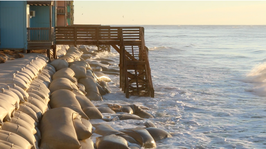
Mayor Burns has led the town since 2015. Before becoming mayor, he owned a real estate company and several other businesses. Burns won his election by promising to stabilize the inlet with a terminal groin and keep it open for boat traffic. Soft-spoken and friendly with a thick mustache and dark eyes, Burns owns three properties next to the inlet, an area with the worst erosion rates on the island. Sandbag walls fortify one of his homes near the inlet.
Homes built near inlets are more vulnerable to changing tides and storms. The town already lost 11 homes to inlet erosion in 2008. The town and 39 property owners constructed a $2.6 million wall of sandbags to prevent the next row from crumbling into the surf.
For some residents of North Topsail Beach, owning affordable shoreline property is worth the risk. “When I tell people I live on an island they think I’m some kind of rich person,” said Connie Pletl. “But I’m not. I’m just a farm girl from West Virginia!”
Affordability was also important to New Jersey native Jay Greenspan. He bought a shorefront condo in 1984 when prices were low. For three decades, Greenspan has spent his summers at North Topsail Beach. In fact, he and his wife Linda moved to North Carolina from New Jersey to be closer to their vacation home, a snug one-bedroom condominium in the Topsail Reef condominium complex near the inlet.
Greenspan said that when they moved in, close to a third of the Topsail Reef condo owners were the same age, and many of them were from New Jersey. Greenspan said North Carolina’s beach property values made the long drive worth it. “We had a crew,” he said. At the time, two rows of dunes and a healthy strip of beach buffered their community from strong winds and tides.
“People nowadays say you shouldn’t build on the coast,” said Greenspan. “But when we bought it, things were vastly different. We weren’t even close to the high tide.”
Hazards like inlets and erosion don’t always come up when house shopping. “Most people learn about how islands work after they’ve built or bought their homes,” said Pilkey. “And then it’s too late.”
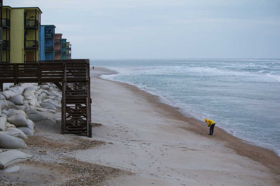
Today the dunes in front of Greenspan’s condo are gone, eaten away by erosion. A 12-foot-high wall of sandbags protects the Topsail Reef condos. Docks straddle the bags, with stairs leading to nothing but crashing waves. A small strip of beach appears at low tide. For a few hours residents roam the wet berm, looking for beach glass and shells before the tide rolls in.
The leadership on North Topsail Beach often disagrees on solutions, but retreating from the coast is usually not an option. “How do you address erosion?” said mayor Burns. “That has been a lifelong question of the geologists and engineers. It’s a problem on all beachfront communities on the East Coast.”
More than half the population growth in the United States occurs on the coast. As more people invest in coastal property, little towns are struggling to meet the demands of this growing constituency, demands that are often at odds with the behavior of a dynamic coastline.